ANPR

Traffic congestion, security breaches, and parking violations plague modern cities daily. Law enforcement agencies struggle to monitor vast areas with limited resources, while traditional surveillance systems remain fixed and limited in scope. Drone license plate recognition offers a transformative solution by combining aerial mobility with artificial intelligence.
Approximately 1,500 police departments across the United States now operate drone programs, marking a significant shift in surveillance capabilities. This technology enables real-time vehicle tracking across multiple city blocks, automated parking enforcement, and rapid response to security incidents. As drones equipped with ALPR systems take flight, they're reshaping how organizations approach traffic management, law enforcement, and large-area surveillance with unprecedented efficiency and coverage.


Drone-based ALPR (Automatic License Plate Recognition) integrates unmanned aerial vehicles with computer vision technology to identify and track vehicle license plates from elevated positions. Unlike fixed ground cameras, aerial systems provide mobile surveillance across vast areas without infrastructure constraints.
Drones equipped with high-resolution cameras capture vehicle images while AI-powered software detects plates, extracts alphanumeric characters through optical character recognition, and matches data against databases in real-time. This technology enables law enforcement, municipalities, and private organizations to monitor traffic, enforce parking regulations, track stolen vehicles, and manage large-area security with unparalleled flexibility and efficiency.
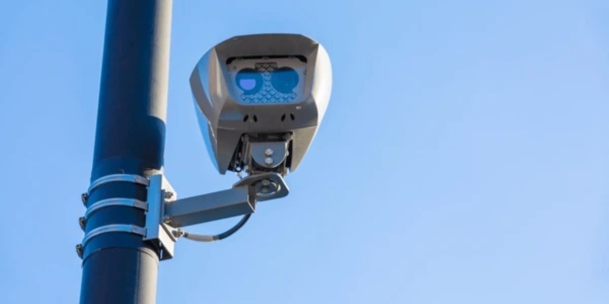
Aerial vision systems mount specialized cameras on drones to capture high-quality visual data from elevated vantage points. These systems combine hardware and software components for comprehensive vehicle monitoring and identification capabilities.
Drone ALPR requires a minimum 12-megapixel camera with optical zoom, capturing 4K video at 30fps to ensure license plates remain readable from 50-100 meters altitude.
Three-axis motorized gimbals compensate for drone movement, wind, and vibration, maintaining steady camera orientation and preventing motion blur during image capture for accurate recognition.
Integrated GPS modules record precise coordinates, altitude, and timestamps for each captured image, enabling location-based analysis and creating comprehensive vehicle movement tracking databases.
High-bandwidth wireless systems (4G/5G or proprietary radio) stream live video feeds to ground control stations, allowing operators to monitor surveillance activities and adjust flight paths.
Advanced systems incorporate infrared and thermal cameras alongside standard RGB sensors, enabling license plate recognition during nighttime operations or low-visibility conditions for 24/7 surveillance.
Integrating ALPR models onto drone platforms requires specialized AI algorithms optimized for aerial perspectives and real-time processing. These models transform raw aerial footage into actionable vehicle intelligence.
YOLOv8, Faster R-CNN, and similar deep learning models scan aerial images to locate license plates within complex visual scenes, identifying plate boundaries regardless of vehicle angle or distance.
Tesseract, PaddleOCR, and custom-trained OCR models extract alphanumeric characters from detected plate regions, converting visual text into machine-readable data for database queries and validation.
Onboard NVIDIA Jetson modules, Intel Neural Compute Sticks, or custom accelerators enable real-time inference directly on drones, reducing latency and eliminating cloud dependency for immediate recognition.
ALPR models require training on diverse aerial datasets that include varying altitudes, angles, lighting conditions, and regional plate formats. This diversity ensures robust performance across a wide range of real-world operational scenarios.
RESTful APIs, SDKs, and middleware connect ALPR models with drone flight control systems, ground station software, and enterprise databases, enabling seamless data flow and automated workflows.

The technical pipeline for drone ALPR involves multiple stages from image capture to data storage. Understanding this workflow is essential for implementing effective aerial recognition systems.
Drones use gimbal-stabilized cameras to capture high-resolution images while compensating for movement, wind, and vibration, ensuring clear license plate visibility from various altitudes.
AI models like YOLOv8 scan captured images to detect and isolate license plate regions, identifying their position regardless of vehicle angle, distance, or surrounding visual clutter.
Once plates are localized, OCR engines like Tesseract extract alphanumeric characters from the plate image, converting visual data into machine-readable text for database queries.
Extracted plate numbers are validated against formatting rules, then matched with databases containing vehicle registrations, stolen vehicle lists, or authorized access records for instant verification.
Processed data, including plate numbers, vehicle images, GPS coordinates, and timestamps, synchronize with cloud platforms for long-term storage, analysis, and multi-agency data sharing.
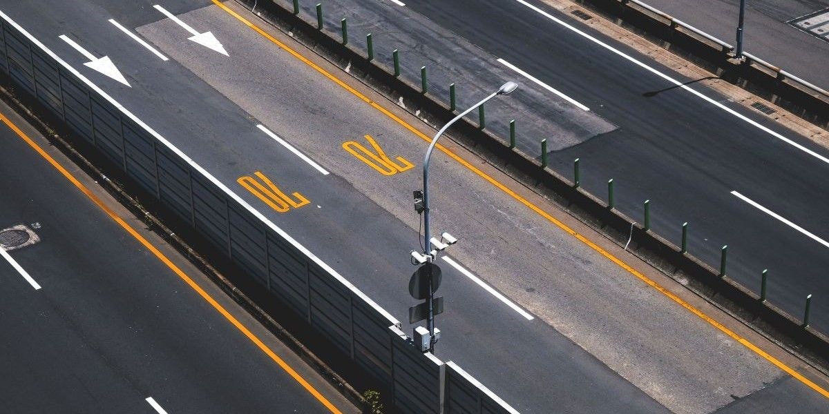
Comparing drone-based and fixed camera ALPR reveals distinct advantages and limitations. This analysis helps organizations choose the appropriate solution for their specific surveillance needs.
Fixed cameras monitor single intersections or roads, while drones cover entire neighborhoods, parking lots, or event venues, adapting flight paths dynamically based on real-time requirements.
Traditional ALPR requires poles, mounting hardware, power lines, and network cabling, costing thousands per location. Drones eliminate infrastructure expenses, offering immediate deployment anywhere.
Installing fixed cameras takes weeks for permitting, construction, and configuration. Drone systems deploy within minutes, scaling rapidly for temporary events, emergencies, or expanding surveillance zones.
Drone ALPR technology serves diverse industries beyond law enforcement. These applications demonstrate how aerial vehicle recognition solves specific operational challenges across multiple sectors.
Municipalities use drone ALPR to monitor traffic flow, identify congestion patterns, optimize signal timing, and enforce traffic regulations across entire districts without installing extensive camera networks.
Police departments deploy drones to track suspects, locate stolen vehicles, monitor border crossings, and gather evidence during investigations with comprehensive aerial surveillance capabilities.
Universities, airports, and commercial facilities use drone ALPR to identify unauthorized parking, verify permits, manage capacity, and automate ticketing across sprawling parking areas efficiently.
Large events employ drone ALPR to screen incoming vehicles, identify threats, manage VIP access, and monitor perimeter security while maintaining situational awareness over vast venues.
Logistics companies track delivery vehicles, monitor warehouse entry/exit points, verify authorized transportation, and optimize routing using drone-based license plate recognition for operational efficiency.

Successful drone ALPR implementation requires specific technical capabilities. These requirements ensure accurate license plate recognition under various operational conditions and regulatory constraints.
Minimum 12-megapixel cameras with optical zoom capabilities are essential for reading plates from 50-100 meters altitude, requiring 30fps video capture for motion clarity.
Optimal recognition occurs at 30-80 meters altitude with drone speeds below 15 mph, balancing coverage area with image clarity while maintaining regulatory compliance.
Drones need onboard GPUs or edge AI processors for real-time image analysis, reducing latency and enabling immediate decision-making without constant cloud connectivity requirements.
Infrared or thermal imaging capabilities compensate for low-light scenarios, while weather-resistant drones maintain operations during light rain, though heavy precipitation reduces accuracy significantly.
High-bandwidth 4G/5G connections enable real-time data streaming, while onboard storage (minimum 256GB) ensures continuous recording when connectivity is limited or interrupted.
Despite technological advances, drone ALPR faces inherent challenges. Understanding these limitations helps organizations set realistic expectations and implement appropriate solutions.
License plate size decreases with altitude, defocusing occurs at varying distances, and perspective distortion from angled shots compromises character recognition accuracy significantly.
Optimal plate reading requires specific viewing angles; excessive tilt or rotation causes character distortion, while gimbal stabilization must compensate for drone movement continuously.
Relative speed between drone and vehicle introduces motion blur, especially when tracking fast-moving cars, requiring higher shutter speeds that reduce light capture capabilities.
Rain, fog, snow, glare, and dust degrade image quality, while wind affects drone stability, high humidity weakens wireless signals, and extreme temperatures impact battery performance.
Different plate formats, fonts, colors, damaged plates, privacy covers, dirt accumulation, and intentional obfuscation techniques reduce recognition accuracy across diverse vehicle populations.
Drone ALPR delivers substantial operational advantages over traditional surveillance methods. These benefits justify investment for organizations requiring flexible, wide-area vehicle monitoring capabilities.
Single drones monitor square kilometers of territory without installing cameras, poles, or wiring, providing comprehensive surveillance across areas where fixed infrastructure is impractical or impossible.
Drones follow vehicles across jurisdictions, adjust positioning for optimal angles, respond to emerging situations, and redirect surveillance focus based on real-time intelligence instantly.
Despite initial investment, drones eliminate ongoing infrastructure maintenance, utility costs, and physical security requirements, while serving multiple locations with reusable, mobile equipment.
Drones deploy within minutes for accident investigations, suspect tracking, disaster response, or search operations, providing immediate aerial reconnaissance and vehicle identification.
Beyond plate recognition, drones capture vehicle type, color, damage, occupancy, traffic patterns, and contextual information, enabling deeper analysis for strategic decision-making.

Drone ALPR raises significant privacy concerns that organizations must address. Responsible implementation requires understanding legal frameworks, ethical obligations, and community concerns.
Alaska, California, Hawaii, and Vermont are currently the only states where courts have held that warrantless aerial surveillance violates residents' constitutional protections against unreasonable search and seizure.
Organizations must establish clear policies defining how long ALPR data is stored, who can access it, under what circumstances, and how citizens can request deletion of their information.
Indiscriminate data collection on innocent citizens raises ethical questions; systems should focus on specific investigations rather than continuous, blanket monitoring of entire populations.
Municipalities should publicly disclose drone ALPR programs, seek community input, publish usage statistics, and establish civilian oversight boards to maintain accountability and public trust.
Organizations must comply with FAA Part 107 regulations, state privacy laws, GDPR for international operations, and industry-specific data protection requirements before deploying systems.
Successful drone ALPR requires selecting compatible hardware platforms. This section identifies supported drones and integration considerations for various operational requirements.
DJI Mavic Series, DJI M200, M300, M600, Inspire Series, Parrot Anafi, Microdrones, Autel EVO II, and Skydio 2 support ALPR integration through HDMI or IP video streaming.
Minimum 4K resolution cameras with optical zoom, adjustable aperture, image stabilization, and infrared capabilities ensure reliable plate recognition across varying distances and lighting conditions.
Onboard NVIDIA Jetson modules, Intel Neural Compute Sticks, or custom AI accelerators enable real-time processing, reducing latency and bandwidth requirements for immediate decision-making.
ALPR drones connect with video management systems, access control platforms, alert notification tools, and central databases through RESTful APIs and standard security protocols.
Organizations may require custom flight control algorithms, specialized AI models for regional plate formats, or proprietary data handling protocols for unique operational requirements.
Folio3 AI delivers tailored Automatic License Plate Recognition systems that seamlessly integrate with your existing surveillance infrastructure, including drone-mounted cameras. Our custom solutions combine advanced machine learning models with flexible deployment options, enabling real-time license plate detection, tracking, and analysis for enhanced security, traffic management, and law enforcement operations across diverse environments.
Our AI-powered system accurately identifies and reads license plates from multiple camera types, including drone-mounted, thermal, and fixed surveillance cameras. It ensures reliable detection across various lighting conditions, angles, and distances with exceptional precision and speed.
Automatically record every vehicle detection with precise timestamps, creating comprehensive entry and exit logs. Our system maintains detailed movement histories for tracking, compliance reporting, and operational analysis without manual intervention or data entry requirements.
Seamlessly connect our ALPR technology with your current surveillance infrastructure, drone fleets, security management platforms, and databases. Our flexible API architecture ensures smooth integration without disrupting your operational workflow or requiring extensive system overhauls.
Instantly notify security personnel, law enforcement, or authorities when flagged vehicles are detected. Our intelligent alert system filters false positives and delivers actionable information, including vehicle details, timestamps, and associated camera feeds for immediate response.
Access comprehensive dashboards with vehicle movement patterns, frequency analysis, and historical data visualization. Our customizable reporting tools help optimize security strategies, traffic flow management, and provide evidentiary documentation for investigations and compliance requirements.
Drones use stabilized cameras to capture high-resolution images, then apply object detection algorithms like YOLOv8 to locate license plates within the frame. Optical character recognition (OCR) engines extract alphanumeric characters, while AI models validate formatting and match against databases for instant vehicle identification.
Legality varies by jurisdiction. Organizations must comply with FAA drone regulations, state privacy laws, and constitutional protections against warrantless surveillance. Only four US states (Alaska, California, Hawaii, Vermont) explicitly protect against warrantless aerial surveillance, making legal consultation essential before deployment.
Law enforcement agencies track suspects and stolen vehicles, municipalities manage traffic and parking, border security monitors crossings, event organizers handle security screening, logistics companies track fleets, and facility managers control access. Universities, airports, and commercial properties increasingly adopt drone ALPR for comprehensive surveillance.
Accuracy depends on multiple factors: optimal conditions (30-80m altitude, clear weather, proper lighting, stable flight) achieve 85-95% accuracy. However, poor weather, motion blur, extreme angles, damaged plates, or obstructions significantly reduce performance. Edge AI processing and custom-trained models improve real-world accuracy substantially.
Yes, Folio3 ALPR solutions integrate with major drone platforms, including DJI, Parrot, Autel, and Skydio, through HDMI connections or IP video streams. Our APIs connect with existing security systems, databases, and business applications. We provide custom development for proprietary platforms and unique operational requirements.
ALPR solutions in Germany are AI-powered vehicle recognition systems designed to read license plates in real time while meeting German operational and regulatory requirements.