AI Drone Solar Panel Inspection Software
We provide AI-powered drone solar inspection software that enables quick, frequent, and accurate inspection of your solar energy farms to ensure longevity and reduce costs.
Utilizing AI for Solar Panel Inspection Drone
Streamline your operations, detect issues with unmatched precision, and maximize your solar farm's potential. Our cutting-edge solar inspection software helps you maximize your solar energy production.
With AI-powered drone solar panel inspections, cut down inspection times and costs drastically and quickly identify potential defects that could compromise power yield by catching them early on.
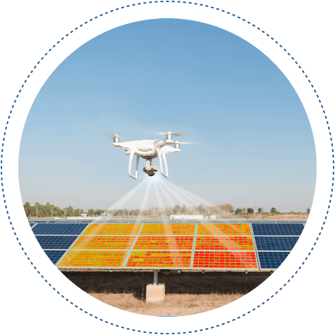
How Does Drone Solar Panel Inspection Work?
Folio3 AI’s solar inspection software uses different drone hardware like thermal imaging cameras to identify various anomalies and detect defects while conducting solar farm inspections. The solution identifies hotspots on cells, and diode failures, shattered or dirty solar panels, and other panel coating or fogging anomalies, etc.

Hotspot Detection
AI algorithms identify and localize hotspots on solar panels, which indicate areas of excessive heat that can reduce efficiency and potentially lead to damage if left unchecked.

Diode Failure Identification
Automatically detect failed bypass diodes in solar panels, which can cause significant power losses and need prompt attention to maintain optimal performance.

Shattered Panel Detection
Recognize and highlight shattered or cracked solar panels using image analysis, enabling swift replacement or repair to avoid further system degradation.

Dirt and Debris Identification
Use AI to detect dirt, dust, and other debris accumulation on solar panels, allowing for timely cleaning to ensure maximum energy absorption and efficiency.

Coating Degradation Detection
Identify signs of panel coating degradation or fogging, which can impact the light transmittance and overall efficiency of the solar panels, prompting maintenance actions.

Thermal Anomaly Detection
Analyze thermal imaging data to find abnormal temperature variations that could indicate underlying issues such as electrical faults or physical damage.

Shadow Analysis
Detect and assess shading impacts from nearby objects, allowing for the adjustment of panel positioning or surroundings to maximize sunlight exposure.

Crack Detection
Identify micro-cracks or fractures in the solar cells that are not visible to the naked eye, preventing long-term damage and efficiency loss.

Corrosion Detection
Spot signs of corrosion on solar panels and mounting structures, ensuring timely intervention to prevent structural failures and maintain system integrity.

Performance Degradation Monitoring
Continuously monitor the performance of solar panels over time, using AI to detect patterns of efficiency loss and recommending proactive maintenance to sustain optimal output.
Watch Our Demo Video For AI Drone Solar Inspection
Utilize drone-captured footage to identify various anomalies while conducting complete solar farm inspections.
Custom Add On Features for Solar Inspections
Solar Drone Inspection software utilizes drone-captured footage to identify various anomalies while conducting complete solar farm inspections.
The solution offers

Live Footage Processing
Utilize AI to analyze live video feeds from drones or stationary cameras, providing real-time detection of anomalies and immediate alerts for any issues identified on the solar panels.

Terrain Mapping
Integrate terrain mapping capabilities to evaluate the geographical features of the installation site, optimizing panel placement and configuration to enhance solar energy capture.

Custom Reports
Allow users to generate custom reports tailored to specific needs, including detailed analyses of performance metrics, detected anomalies, maintenance activities, and energy outputs.
Benefits
AI-powered drone inspection provides great cost and efficiency advantages to solar energy farms and operations. Traditionally, inspections would involve a team of experts checking each individual panel with thermal cameras and recording faults which in the case of most farms may take from several weeks to months just for inspection.

Minimize Cost of Inspection

Find Problems Faster

Conduction Inspections with Ease

Maximize Equipment Longevity
Manual Solar Panel Inspection Challenges
Overcome Operational and traditional inspection challenges with AI powered solar panel drone inspection

Logistical Constraints
Traditional inspections struggle with covering vast solar farms. AI drones overcome this challenge by swiftly and consistently covering large areas without any logistical hassles.

Adverse Conditions
Environmental factors like weather or terrain can hinder human inspectors. AI drones operate in adverse conditions, ensuring inspections are conducted consistently regardless of external factors.

Human Error Reduction
AI eliminates the potential for human error, ensuring a higher degree of accuracy in identifying issues and recommending maintenance actions.

Prompt Action
Instant data processing enables quick identification of panel issues, allowing for timely maintenance and repairs that improve overall energy output.

Safety Enhancement
AI drone inspections eliminate the risk to human safety in hazardous environments, ensuring inspections are conducted without any harm.
Other AI Drone Applications
We have built solutions to cater to a number of different use cases and scenarios.

Utilize drones to identify and map terrain characteristics and anomalies. From identifying buildings and structures using LIDAR tech to detecting anomalies like landslides, etc.

Leverage AI to detect pests, diseases, and other factors like water distribution to maximize yield and efficiency while driving down the costs and wastage.

Maximize the efficiency of your ranch by keeping a count of your cattle and livestock, identify predators in your geofenced area, and monitor the quality of pastures.
Pipeline Inspection
Conduct timely and quick inspections of your pipeline infrastructure by identifying anomalies such as damage, spillage, illegal encroachment, and theft.

Conduct quick and accurate inspections of wind turbines for the timely detection of damage and indications of wear.
AI Drone
Solar Panel Inspection
Learn more about the solution
And standard features.
Explore our other pre-built models
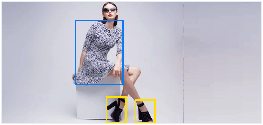
Apparel Detection
Detect and identify clothing and accessories, such as shirts, trousers, shoes, and headgear, etc.
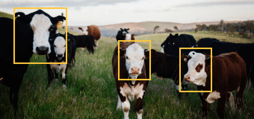
Animal Detection
Accurately detect, classify, and count animals such as livestock in video and image data.
Do you require AI Drone Solar Panel Inspection Services?
Drop us a line and our experts will provide you with a free 1-hr consultancy and discuss your project requirements!
Why Choose Folio3 for Solar Panel Inspections?
With over a decade of experience in delivering digital transformation solutions in different verticals, from AI solutions, enterprise applications, and mobile apps, we have the expertise to become the technology provider you need to create a lasting competitive advantage.

Highly Customizable
Folio3 offers extensive expertise and experience by leveraging in-depth industry insight. We help clients achieve maximum potential by predicting loss points and providing actionable vision.

Competitive Rates
Our team of professionals includes more than 300 skilled developers with the right certifications and qualifications to address your every requirement.

One-Stop-Shop
Our extensive list of satisfied customers includes companies from a wide range of industries both public and private, including healthcare, manufacturing, retail and traffic management.

Enterprise Ready
Our solutions are built to be ready to scale as your enterprise grows larger.
AI Drone Solar Panel Inspection FAQs
How is AI used in drones?
AI enables drones to do more than just capture images or videos captured with the mounted camera. With AI, drones can now perceive and identify areas enabling them to map areas, track objects, detect anomalies, and provide analytical reports.
How are drones used for inspections?
Once the visual data is captured by the drone, the AI-powered software analyzes the footage/images to identify specific characteristics like objects, anomalies, or other factors like temperature ranges and after crunching that data presents it in insightful reports. Thereby, greatly reducing the time and effort required by conducting a manual inspection.
Are drone surveys accurate?
For drone surveying, accuracy can mean different things. Like, for conventional photogrammetric tech it can be higher resolution images as those are used to create 3D planes. Whereas advanced LiDAR technology might offer the same pixel sizes but offers a lot more useful data of topological characteristics. So, the technology being deployed goes a long way in determining the accuracy of the surveys.

